

 Detailed Description of the current Version
 Multi Language Support
 User Interface Details / Screenshots
 Prices NTv2Poly
 Click here to
 Click here for the
 History of Modifications and Enhancements
The history file contains a detailed version history with all modifications, enhancements and additions of the actual software.
Using NTv2 grid files it is possible to transform points from one coordinate reference system to another with very high accuracy. An NTv2 file contains one or more quadrangular coordinate grids which are defined in the NTv2 headers. Instead of a rectangular area only an embedded polygonal area should and must be covered, for example, a state territory within the country borders.
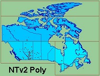
The program NTv2Poly realizes Polygonal Validity Scopes in NTv2 files. Using so prepared NTv2 files, coordinates outside the validity scope can be excluded from calculations or they can be acknowledged by a warning. This works with coordinate transformations using the geospatial software TRANSDATpro and GeoDLL by KilletSoft and with many GIS programs which support Polygonal Validity Scopes.
The Polygonal Validity Scope is realized with a shape file, which contains the outlines of the scope as polygons. The file format Shape is developed by ESRI as a format for geographical objects. For example, in the shape file the border outlines of a country may be stored, which represent the polygonal scope for the NTv2 file used in that country. Using the program NTv2Poly the polygons of the shape file and the quadrangular surface of the NTv2 file are superimposed one on the other and processed in an ingenious manner.
The term "exopolygonal entry" used in the course of the text stands for the entry of a characteristic value in a grid mesh of an NTv2 file to exclude this grid mesh from the scope of the NTv2 file. It follows that all grid meshes with exopolygonal entries are invalid. The program NTv2Poly marks all grid meshes that lies outside the polygons of the used shape file as invalid by introducing exopolygonal entries in the NTv2 file.
By using exopolygonal entries in the shift values or in the accuracy values of the NTv2 file, there are two methods for realizing Polygonal Validity Scopes, which both are supported by the program. The two methods differ considerably in their effects.
The use of Polygonal Validity Scopes is described in detail in our  Work sheet "Proposal for using Polygonal Validity Scopes in NTv2 grid files".
The program has a user-selectable multi language interface and comes with extensive online help. The program can be run on most common networks and it is possible to use Terminal Services on WINDOWS Servers. In case of a network installation the clients are installed automatically by the program.
The program NTv2Poly is equipped with a modern graphical user interface of which handling is to understand intuitively.
For each window detailed help texts can be shown.
The detailed electronic documentation of the program NTv2Poly is available in both English and German language.
However, the user interface can be represented in many languages.
For this purpose, external language files are used.
When starting the program, it notes which language files are available in the calling directory.
The found languages then are provided for selection in a list box.
By  creating new language files, new languages can be added by users to the program NTv2Poly at any time.
The program NTv2Poly can be run on most common networks. The client installations works automatically. It is possible to use Terminal Services on WINDOWS Servers like e.g. "Citrix Terminal Server".
Pricing and ordering information can be found in the  Price list.
For available licensing options have a look to the
  License page.
Order the program with the electronic
  Order Form.
The free test version of the program with a detailed user manual can be  downloaded as ZIP packed file by the Internet.
Managing Director Fred Killet explains why you should never use an  illegal version of our geodetic program NTv2Poly.
 In order that you are always well informed about our company, we write actual news, current information and special offers here into this column.
 Read more...
 Read more...
 Description ORTWIN...
 Description TOPOWIN...
 Register now...
 Read more...
 Read the work sheet...
 Read the work sheet...
 Read the work sheet...
 Read the Press Release...
 To the NTv2 collection...
