

 Download WORD file and JPG images of the second edition for publication
 The geographic Coordinate Reference System uses an ellipsoidal model of the earth to describe the position of objects with two- or three-dimensional coordinates on on the earth's surface.
In the general linguistic usage the abbreviation CRS for the Coordinate Reference System is common.
The designation "Coordinate Reference System" is composed of the terms "Coordinate System" and "Reference System".
Thereby the mathematical calculation and representation of the coordinates with numerals is realized by the geodetic Coordinate System.
The position of the synthetic earth ellipsoid in relation to the real earth is described with the geodetic Reference System which is often also called a geodetic Datum.
In order to accurately measure the surface of the earth in an area, surveyors have created there over time a complex network of measuring points firmly embedded in the ground, called reference points or benchmark monuments.
By measuring the angles and distances between the reference points, the latitude and longitude have been determined for each of them.
Relating those reference points into a group forms the basic data set for a Reference Frame.
One or more Coordinate Reference Systems calculated from this Reference Frame are the basis for all geodetic tasks and for all types of surveying, mapping and navigation in the surveyed area.
Thereby the Coordinate System, i.e. the representation form of the coordinates, can indeed vary.
For the professional handling of coordinates, additional information is required besides the coordinate values in order to avoid incorrect positioning of the objects described by the coordinates.
The ISO 19111 standardizes the spatial referencing by coordinates in the Geographic Information Technology.
It specifies which descriptive information must be transferred when coordinates are exchanged and refers to this as Coordinate Reference System (CRS).
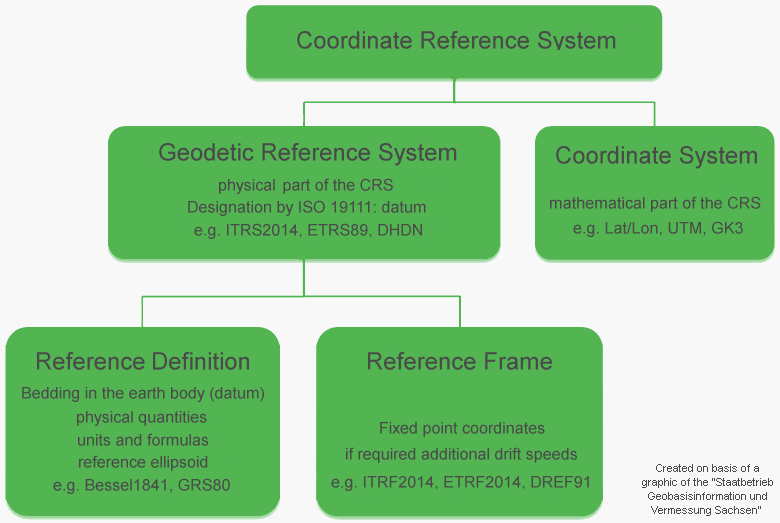
The Coordinate Reference System always consists exactly of a geodetic Reference System and a Coordinate System.
Coordinate Reference System = Geodetic Reference System + Coordinate System
The components of the Coordinate Reference System and the requirements for the data transfer of coordinates are illustrated schematically in the following diagram.
 The Geodetic Reference System - in the parlance of the ISO 19111 called as Geodetic Datum - is the physical component of the Coordinate Reference System (e.g. ETRS89, DHDN, RD/83, 42/83).
The Coordinate System is the mathematical component of the Coordinate Reference System.
It is defined by mathematical formulas which assign equivalent coordinates as numerical values to point positions (e.g. GK3, GK6, UTM, Lat/Lon, X/Y/Z).
Coordinates are only unambiguous if the Coordinate Reference System is completely specified.
The use of different parameters of the Coordinate System, the geodetic Reference System, the Reference Definition or the Reference Frame will lead to more or less different results when transforming coordinates.
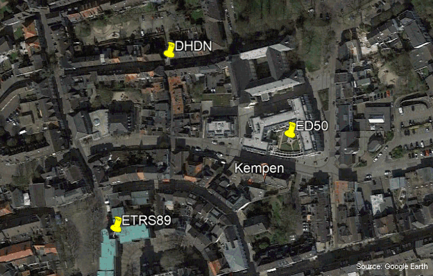
In the following map, as an example, the same geographic coordinate is shown in each of the different Reference Systems ETRS89, DHDN and ED50.
As can be seen, the points are a several hundred meters apart.

In many countries, improved and thus more accurate variants of the same reference system have been made available over time.
The different variants are usually identified by year numbers or accuracy and area information.
When using different variants of the reference system, the location difference is usually small and is within the range of millimetres to meters.
To correctly convert coordinates to another CRS, the same reference system must be used that was current when the coordinates were originally recorded.
The Helmert Seven Parameter Set is commonly used to define the reference system.
In recent years, NTv2 grid files have been increasingly used to convert between reference systems.
These offer very high accuracies, particularly in small-scale target areas, such as the Federal States in Germany.
Accuracy, or rather inaccuracy, of the reference system is the result of minor deviations in the determination of points in the surveying process.
For example, the DHDN was determined in the 19th century by measuring of triangular grids with optical theodolites.
This measurement method, which is inaccurate according to today's understanding, led to relatively large distortions in the geodetic network.
The reference system is the mathematical basis to be able to calculate out these distortions and to create a homogeneous network on the underlying earth ellipsoid.
As examples several variants of the reference system DHDN, which is commonly used in Germany, with different accuracies are shown here.
Among others, the variants listed here are used in the program TRANSDATpro and in the Geodetic Development Kit GeoDLL (both see below) with the following designations:
DHDN/PD (DE 1995 ±5m), Rauenberg, Bessel
DHDN/PD (DE 2001 ±3m), Rauenberg, Bessel
DHDN/PD (DE Old states South ±1m), Rauenberg, Bessel
DHDN/PD (DE Old states Center ±1m), Rauenberg, Bessel
DHDN/PD (DE Old states North ±1m), Rauenberg, Bessel
DHDN90 (DE 2007 ±3.0m), Rauenberg, Bessel
DHDN90 (DE NTv2 BeTA2007 ±0.5m), Rauenberg, Bessel
DHDN90 (DE-BW NTv2 BWTA2017 ±5cm), Rauenberg, Bessel
DHDN90 (DE-BY 2019 NTv2 BY_KanU_Bges ±2cm), Rauenberg, Bessel
A special feature is to be considered with the conversion of coordinates of a fixed Reference System into the Reference System WGS84, which refers to the gravity centre of the earth, and with the appropriate back calculation.
The WGS84 is a dynamic Reference System that is influenced by the continental drift of the different continental plates.
This process describes the slow movement, splitting, and unification of continents on the earth's globe.
The time course of this movement is constantly documented in the form of ITRS epochs.
In addition to the parameters already described, the reference frame of the continent with the ITRS epoch at the time of the measurement or coordinate transformation is required for calculations from and into WGS84.
WGS84 coordinates can be accurately transformed to a fixed Coordinate Reference System only if the ITRS epoch of the WGS84 coordinates is known.
As an example, the Reference System ETRS89 which is fixed for the Eurasian Plate is considered here in more detail.
At the 1989.0 epoch, the ITRS and the ETRS were identical.
At this time, ETRS89 has been defined for the Eurasian Continental Plate and has been identified with the suffix 89.
ETRS89 is firmly tied to the Eurasian Plate via fundamental stations and moves with about 2.5 cm per year over the global system defined by WGS84.
It follows that the coordinates from an accurate current GPS measurement in the WGS84 Reference System in Europe can deviate by up to 80 cm from the actual coordinates in ETRS89.
Here are some examples of the correct designation of a Coordinate Reference System:
UTM coordinates on the ETRS89 datum
Gauss-Krueger coordinates with three degree meridian stripes on the DHDN90 datum
Gauss-Krueger coordinates with six degree meridian stripes on the S42 datum
Geographical coordinates in DMS notation on the WGS84 datum at epoch 2005.
Another possibility for the unique naming of Coordinate Reference Systems is the use of EPSG codes.
EPSG is a system of globally unique key numbers for Coordinate Reference Systems and other geodetic data, which was originally established by a working group of European oil and gas exploration companies (European Petroleum Survey Group Geodesy).
The information on the EPSG codes is available in a publicly accessible online database.
Here are some examples of EPSG codes of Coordinate Reference Systems and their usage:
| 3857 | WGS84 / Pseudo-Mercator |
| is used by Google Maps, OpenStreetMap and map providers on the web | |
| 4326 | WGS84 / Geographical Coordinates |
| is the worldwide system for GPS | |
| 25832 | ETRS89 / UTM zone 32N |
| is used from 6°E to 12°E in Germany, Austria and Switzerland | |
| 25833 | ETRS89 / UTM zone 33N |
| is used from 12°E to 18°E in Germany and Austria | |
| 31466 | DHDN / Gauß-Krueger zone 2 |
| is used west of 7,5°E in Germany | |
| 31467 | DHDN / Gauß-Krueger zone 3 |
| is used from 7,5°E to 10,5°E in Germany |
The geodetic program  TRANSDATpro can convert coordinates between many Coordinate Reference Systems.
The same applies to the Geodetic Development Kit
  GeoDLL, which allows the embedding of geodetic functions, e.g. coordinate transformations, into own software.
For coordinate transformations with the WGS84 Reference System, continental drift is considered in both tools by applying ITRS epochs.
Detailed information about the software and the possibility to download trial versions can be found on the Internet site of KilletSoft.
The installation of the software is very easy and can be done with just a few clicks.

 Dipl.-Ing. Fred Killet
Killet GeoSoftware Ing.-GbR (KilletSoft)
Escheln 28a
47906 Kempen (Germany)
https://www.killetsoft.de
 In order that you are always well informed about our company, we write actual news, current information and special offers here into this column.
 Service and Maintenance...
 Description ORTWIN...
 Description TOPOWIN...
 Read more...
 Read more...
 Register now...
 Read more...
 Read the work sheet...
 Read the work sheet...
 Read the work sheet...
 Read the Press Release...
 To the NTv2 collection...
