

 Google Translator to read in other languages!
 Download Press Release as MS WORD file

 Kempen, Rheinland -
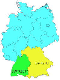
Etwas später als geplant sind im März 2019 die zuvor vom "Bayerischen Landesamt für Digitalisierung, Breitband und Vermessung" veröffentlichten Testdateien BY-KanU in produktive NTv2-Dateien für den Datumsübergang von DHDN90 nach ETRS89 überführt worden.
Bereits im Jahr 2017 hat das "Landesamt für Geoinformation und Landesentwicklung Baden-Württemberg" ein hochgenaues NTv2-Gitter fertig gestellt.
KilletSoft hat darüber im
  Januar 2018 berichtet.
Die NTv2-Dateien von Bayern haben eine Maschenweite von nur einer Bogensekunde, das sind ca. 30 Meter.
Wegen den engen Gittermaschen ist bei Koordinatentransformationen mit diesen NTv2-Dateien eine extrem hohe Genauigkeit im Bereich weniger Zentimeter gewährleistet.
Die NTv2-Dateien können kostenfrei von der Internetseite des Bayerischen Landesamtes
  heruntergeladen werden.
Sie werden als Gesamtdatei für Bayern oder als je eine Datei pro Regierungsbezirk bereitgestellt.
Die hochgenauen Transformationen mit den NTv2-Dateien des Bayerischen Landesamtes sind in dem Koordinatentransformationsprogramm TRANSDATpro und dem Geodetic Development Kit GeoDLL von KilletSoft integriert.
Dabei wurde der Umstand berücksichtigt, dass die hier genannten NTv2-Dateien sehr groß sind.
Bei einigen Dateien sprengt die Dateigröße den mit einem "long integer" adressierbaren Dateibereich von rund 2,2 Gigabyte.
KilletSoft hat seine Software dahingehend angepasst, dass auch NTv2-Dateien jenseits der Größe von 2,2 Gigabyte genaue Ergebnisse bei gleichzeitig hoher Verarbeitungsgeschwindigkeit liefern.
Ausführliche Informationen über geodätische Software von KilletSoft erhalten Sie auf der Internetseite  https://www.killetsoft.de.
Außerdem finden Sie auf der Seite
  https://www.killetsoft.de/p_trdn_e.htm die weltweit größte Zusammenstellung der frei verfügbaren NTv2-Dateien mit ausführlichen Erläuterungen und der Möglichkeit zum direkten download.
 In order that you are always well informed about our company, we write actual news, current information and special offers here into this column.
 Service and Maintenance...
 Description ORTWIN...
 Description TOPOWIN...
 Read more...
 Read more...
 Register now...
 Read more...
 Read the work sheet...
 Read the work sheet...
 Read the work sheet...
 Read the Press Release...
 To the NTv2 collection...
