

 Download Press Release as MS WORD file
![]() Since the middle of last year Killet GeoSoftware Ing.-GbR release their Geodetic Development Kit GeoDLL with geodetic calculations of Time Zones and Daylight Saving Times for embedding in your own computer programs.
New and until now worldwide unique in the current GeoDLL version 10.15 is the consideration of Maritime Territorial Limits in determining country-specific Time Zones from geographical coordinates.
Thus the Time Zone of a country can be accurately determined when entering the respective Maritime Territorial Zone.
Since the middle of last year Killet GeoSoftware Ing.-GbR release their Geodetic Development Kit GeoDLL with geodetic calculations of Time Zones and Daylight Saving Times for embedding in your own computer programs.
New and until now worldwide unique in the current GeoDLL version 10.15 is the consideration of Maritime Territorial Limits in determining country-specific Time Zones from geographical coordinates.
Thus the Time Zone of a country can be accurately determined when entering the respective Maritime Territorial Zone.
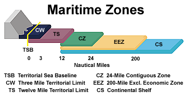
© According to a graphic of the Commonwealth of Australia
The new GeoDLL calculates Time Zones alternatively including the Territorial Sea Baseline, the Three Mile Territorial Limit, the Twelve Mile Territorial Limit, the 24-Mile Contiguous Zone and the 200-Mile Exclusive Economic Zone.
Outside these Maritime Zones, international offshore Time Zones with the designations Alpha to Zulu are calculated.
The Sea Baseline follows the low-water line along the coast of a state.
It is the base to measure the seaward limits of a state's territorial sea and all other Maritime Zones.
From country to country different the Three and Twelve Mile Territorial Limits define sea areas which are regarded as the sovereign territory of the state.
In the 24-Mile Contiguous Zone a state can exert limited control, for example police powers with respect to immigration and customs control.
Inside the 200-Mile Exclusive Economic Zone a state has control of all economic resources, for example fishing, mining of natural resources and exploration.
The 408 worldwide Time Zones follow predominantly the borders and maritime territorial lines of countries or their subdivisions.
GeoDLL can calculate Time Zones from geographic coordinates that comes for example from a GPS receiver.
From the coordinates the Time Zone is determined involving the coastline of the desired Maritime Zone with high accuracy.
Thus the clocks of a ship, plane or other means of transport can be set depending on the position and the Daylight Saving Time status of each country automatically to local time.
Map of 408 onshore Time Zones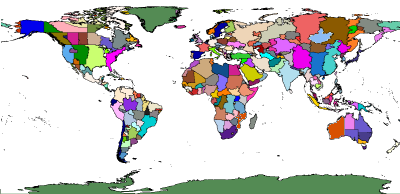
Plate Carrée EquiRectangular Projection
© Killet GeoSoftware Ing.-GbR
Time Zones supported by GeoDLL are based on a uniform naming convention, designed by Paul Eggert.
They correlate to offsets from Coordinated Universal Time (UTC) as a number of hours, such as "America/New_York, UTC-5".
Many countries use Daylight Saving Time (DST) in bright seasons, typically by changing clocks one hour forward.
Unfortunately, the start and end dates of Daylight Saving Time in countries are handled differently.
GeoDLL takes this into account and calculates the Time Zone parameters UTC, DST and start/end dates of the Daylight Saving Period for all countries and Time Zones exactly.
An online-manual of GeoDLL with detailed function descriptions for software developers is available at https://www.killetsoft.de/h_geodll_e/handbuch_e.htm.
 In order that you are always well informed about our company, we write actual news, current information and special offers here into this column.
 Read the Synopsis...
Service and Maintenance...
Description ORTWIN... Description TOPOWIN...
Read more...
Read more...
Register now...
Read more...
Read the work sheet...
Read the work sheet...
Read the work sheet...
Read the Press Release... To the NTv2 collection...
Read the Synopsis...
Service and Maintenance...
Description ORTWIN... Description TOPOWIN...
Read more...
Read more...
Register now...
Read more...
Read the work sheet...
Read the work sheet...
Read the work sheet...
Read the Press Release... To the NTv2 collection...
 Company