

 Download Press Release as MS WORD file
![]() Killet GeoSoftware Ing.-GbR releases the new Dynamic Link Library GeoDLL 14.7 with geodetic calculations of Time Zones and Daylight Saving Times, which handles the more than 400 different Time Zones all over the world.
The Time Zones are primarily longitude dependent, but secondary follow the boundaries of countries or their subdivisions.
GeoDLL is able to calculate Time Zones from geographic coordinates.
Map of 408 onshore Time Zones
Killet GeoSoftware Ing.-GbR releases the new Dynamic Link Library GeoDLL 14.7 with geodetic calculations of Time Zones and Daylight Saving Times, which handles the more than 400 different Time Zones all over the world.
The Time Zones are primarily longitude dependent, but secondary follow the boundaries of countries or their subdivisions.
GeoDLL is able to calculate Time Zones from geographic coordinates.
Map of 408 onshore Time Zones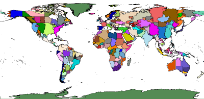
Plate Carrée EquiRectangular Projection
© Killet GeoSoftware Ing.-GbR
The correct Time Zone is detected also in the peripheral regions of the zone surfaces with high precision.
Time Zones supported by GeoDLL are based on a uniform naming convention, designed by Paul Eggert.
They correlate to offsets from Coordinated Universal Time (UTC) as a number of hours, such as "America/New_York, UTC-5".
Many countries use Daylight Saving Time (DST) in bright seasons, typically by changing clocks one hour forward.
Unfortunately, the start and end dates of Daylight Saving Time in countries are handled differently.
GeoDLL takes this into account and calculates the Time Zone parameters UTC, DST and start/end dates of the Daylight Saving Period for all countries and Time Zones exactly.
Software developers thus have a further opportunity to embed geodetic functionality into their own programs.
But the main feature of GeoDLL are precise Coordinate Transformations all over the world.
An online-manual of GeoDLL with detailed function descriptions is available on https://www.killetsoft.de/h_geodll_e/handbuch_e.htm.
 In order that you are always well informed about our company, we write actual news, current information and special offers here into this column.
 Read the Synopsis...
Service and Maintenance...
Description ORTWIN... Description TOPOWIN...
Read more...
Read more...
Register now...
Read more...
Read the work sheet...
Read the work sheet...
Read the work sheet...
Read the Press Release... To the NTv2 collection...
Read the Synopsis...
Service and Maintenance...
Description ORTWIN... Description TOPOWIN...
Read more...
Read more...
Register now...
Read more...
Read the work sheet...
Read the work sheet...
Read the work sheet...
Read the Press Release... To the NTv2 collection...
 Company