

 Download Press Release and Work sheet as PDF and MS WORD file
 When conducting Internet research, it is often assumed that the WGS84 reference system used for GPS measurements and the European reference system ETRS89 are virtually identical and that no coordinate transformation between the two systems is necessary.
In fact, the positions calculated by these two reference systems currently differ by nearly one meter.
This is not a problem for navigation or geoinformatics, as the need for precision is negligible and conversion between the two systems is therefore unnecessary.
However, this difference must be taken into account for high-precision surveying work in the context of geodetic spatial referencing and for data with legal effect, such as the cadastre.
This article addresses the following two questions:
The target audience for this scientific article includes users with geodetic expertise, developers of geodetic software, GIS consultants and engineering firms, as well as GIS managers in government agencies who deal with GPS surveying and/or various coordinate reference systems (CRS).
|
Abbr.: CRS Coordinate Reference System A CRS contains two different elements - the Coordinate System and the Reference System (datum). The Coordinate System describes how the coordinates of the CRS are expressed by calculation rules and projection equations. Examples: Ellipsoidal coordinates, Cartesian coordinates, UTM, Lambert, Gauss Kruger. The Reference System defines how the CRS is related to the earth. Examples: WGS84, NAD84, NAD27, ETRS89, ED50. |
Unified geodetically Europe
INSPIRE (Infrastructure for Spatial Information in the European Community) is a European commission with the goal to create a unified spatial data base for all of Europe.
Background of this scientific article is that in all domains of geodesy by INSPIRE guidelines required conversions of local CRS of the European countries to Europe-wide uniform CRS, based on the Reference System ETRS89, must be done.
Under European legislation INSPIRE proposes for different applications and scales following CRS:
The Reference System WGS84, used for GPS measurements, is based on the global International Terrestrial Reference System ITRS that is fixed on the earth's center of mass.
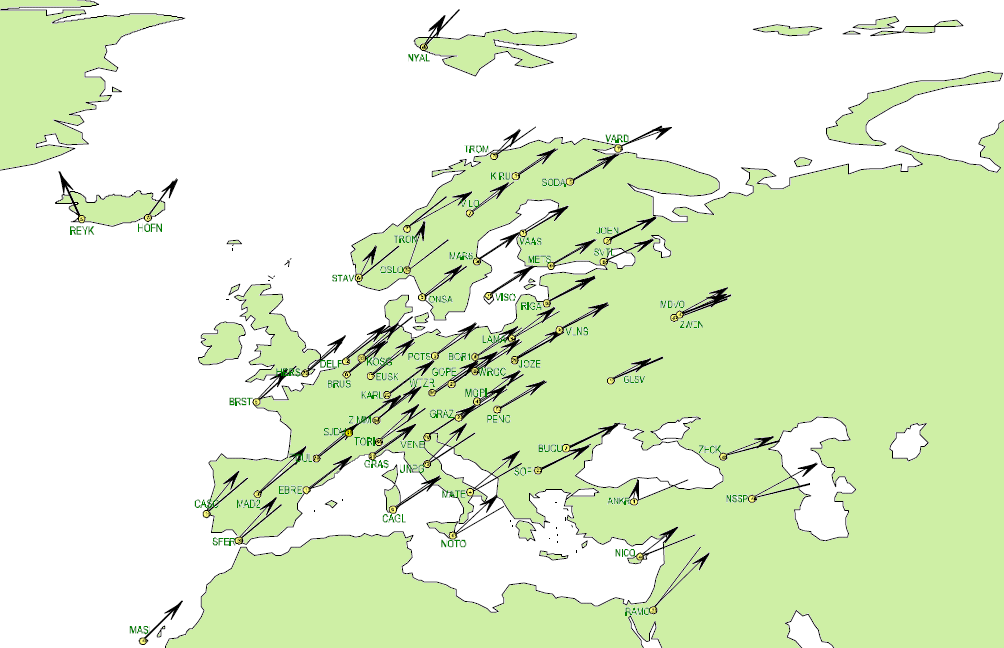
Due to plate tectonics, the Eurasian continent within the ITRS is slowly moving upon the surface of the earth in a north-easterly direction.
ETRS89 is a geocentric Reference System for Europe based on the state of the International Terrestrial Reference System ITRS as of January 1, 1989.
As the Eurasian continental plate is largely static, ETRS89 provides Europe with a Reference System that is uniform and time-independent.
The relationships between coordinates located on the stable part of the European plate thus remain unaltered with ETRS89.

Img. 1: Difference between ITRS and ETRS89
Source: Prof. Dr.-Ing. Wolfgang Augath;
Beiträge des Vermessungswesens zur Ortung
und Navigation im Wandel; Dresden
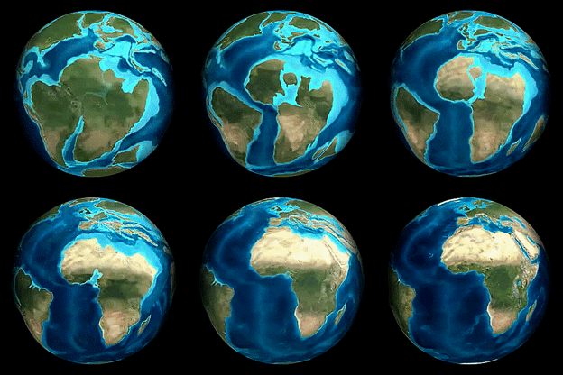
Continental Drift
Since ETRS89 was realized until today (2024), a difference of 80 to 90 centimeters has accrued between WGS84/ITRS and ETRS89 which continues to grow dynamically at a rate of approximately 2.5 centimeters annually.
The difference varies depending upon the location of a given coordinate on the Eurasian plate, because the continent slowly but steadily rotates around the Earth center of mass.
The vectors representing displacements and the angles representing rotations are graphically depicted in Img. 1.
Accuracy of GPS measurement methods
Converting GPS coordinates to ETRS89
For direct measurements the conversion to ETRS89 is usually not necessary, as it in terms of the systemic high inaccuracy of several meters would not lead to a significant improvement.
Here, the equating of WGS84 and ETRS89 can be tolerated.
However, to maintain the high accuracy of DGPS and SAPOS, for the transformation of GPS coordinates from the WGS84/ITRS Reference System to ETRS89 exact transformation parameters are required.
To this end, precise parameter sets are calculated and regularly made public as ITRS annual realizations or WGS84 epochs.
The WGS84/ITRS GPS coordinates are converted to ETRS89 with their given epoch's parameter set.
For an exact calculation, it is therefore necessary to know the epoch, that is, the year the GPS data was implemented.
These realizations are issued using the year in the form of ITRS89 for the year 1989, successively up to ITRS24 for the year 2024 and annually ongoing.
TRANSDATpro supports GPS epochs
KilletSoft's TRANSDATpro coordinate conversion program provides a module "GPS Measurements - ITRS epochs" that can carry out very precise Coordinate Transformations from current GPS measurements to the Reference System ETRS89 using the parameter set ITRSyy for the current year.
In addition, the module enables the transformation of GPS coordinates to ETRS89 of any older epochs since 1989 and of future epochs.
The inverse transformation of ETRS89 to any WGS84/ITRS epochs is also possible.
To align GPS coordinates, it is also possible to transform data from one WGS84/ITRS epoch to another.
For all this special transformations various geographic notations and UTM coordinates are used as Coordinate Systems.
The ITRS parameter sets available in TRANSDATpro will be dynamically continued in the coming years.
By using the ITRS parameter set of the current year for all conversions between WGS84 and ETRS89 or the local systems of the European countries the highest possible accuracy will be reached.
Current WGS84 coordinates can be converted without loss of accuracy due to continental drift e.g. in German Gauss Krueger coordinates using the Reference Systems DHDN, RD, PD and S42.
The same applies in the different countries modules for the local CRS all European countries.
Equivalent to the European continent (ETRS89), TRANSDATpro also supports annual ITRS parameter sets for the North American continent (NAD83), the South American continent (SIRGAS2000), and the Australian continent (GDA2020).
A sample calculation with TRANSDATpro

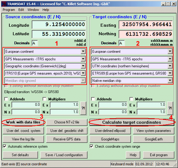
Img. 2: Sample calculation with TRANSDATpro
For example, here will be shown how to convert highly accurate GPS coordinates from an earlier epoch to the Europe-wide CRS UTM/ETRS89 specified by INSPIRE with consideration of the continental drift.
It is assumed that a large amount of GPS coordinates are stored line by line in a text file.
The coordinates are present as Geographic Coordinates in the degree notation in WGS84 datum.
In this example the GPS campaign took place in 2010, which is the ITRS epoch ITRS10.
The settings marked with 1 must be selected for the source coordinates.
The converted coordinates should be stored into a new file as UTM coordinates in the Reference System ETRS89.
Mark 2 shows the settings needed in TRANSDATpro.
Then a click on the button 3 opens the window for the file settings.
There all necessary settings and formats for the input file and for the output file can be made.
Clicking the button 4 starts the Coordinate Transformation.
A moment later accurately calculated results with consideration of the continental drift between the years 1989 and 2010 are contained in the output file named before.
By the way: The last calculated coordinate can be viewed at any time on OpenStreetMap™ and Google Maps / Earth™ maps and satellite images.
This requires that a connection to the Internet is present or the Google Earth™ program is installed on the computer.
The TRANSDATpro Program
 TRANSDATpro was developed by the German company Killet GeoSoftware Engineering.
The program is in productive use in Europe, the United States and other countries worldwide for the professional conversion between international and national Coordinate Systems and Reference Systems - fast and with highest quality results.
TRANSDATpro supports all by the INSPIRE directive prescribed ETRS89 conversions with NTv2 grid data, e,g. Gauss-Kruger / DHDN to UTM / ETRS89 with BeTA2007.
The NTv2 standard with national grid files is worldwide full supported.
Apart from the given worldwide and state-specific systems, your own personal Coordinate Systems and geodetic Reference Systems can be defined with Helmert (Bursa / Wolf, ISO19111) or Molodensky Parameters.
Calculations can be performed with coordinates entered directly or loaded from files in various formats (Text, CSV, SDF, dBase, ArcShape and ArcGenerate).
For more detailed information, please go to our website
  https://www.killetsoft.de/p_trda_e.htm.
The Development Kit GeoDLL
Developers of geodetic programs and applications may also access the Geodetic Development Kit GeoDLL which contains precise functions for topics like 2D and 3D coordinate conversions, change between datum or Reference Systems, meridian swaps, geodetic tasks, distance calculations, Digital Elevation Models as well as support of NTv2.
GeoDLL is distributed as DLL for 32bit and 64bit WINDOWS platforms and as source code in C / C++.
For more detailed information, please go to our website  https://www.killetsoft.de/p_gdla_e.htm.

 Author
Dipl.-Ing. Fred Killet
Killet GeoSoftware Ing.-GbR (KilletSoft)
Escheln 28a
47906 Kempen (Germany)
https://www.killetsoft.de
 In order that you are always well informed about our company, we write actual news, current information and special offers here into this column.
 Read more...
 Read more...
 Description ORTWIN...
 Description TOPOWIN...
 Register now...
 Read more...
 Read the work sheet...
 Read the work sheet...
 Read the work sheet...
 Read the Press Release...
 To the NTv2 collection...
