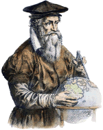
Gerardus Mercator
"Gradus latitudinum versus utrumque polum paulatim auximus pro incremento parallelorum supra rationem quam habent ad aequinoctialem."
"Wir haben die Projektion der Breitengrade zu beiden Polen hin allmählich in dem Maße vergrößert, wie die Breitenparallelen in ihrem Verhältnis zum Äquator zunehmen."
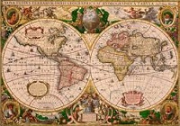
Mercator Weltkarte von 1569
Gheert de Cremer alias Gerardus Mercator schrieb den obigen Satz stolz in die Legende seiner berühmten Weltkarte von 1569.
Dieser große Wissenschaftler löste damit das wichtigste kartographische Problem seiner Zeit.
Es war ihm gelungen, den Globus mit all dem, was man damals über die Länder und die Gewässer wusste, winkeltreu auf einem flachen Blatt Papier abzubilden.
Damit legte er den Grundstein für die moderne Geodäsie und Kartografie.
Im Zuge der Globalisierung entdecken Handel, Industrie und Dienstleister zunehmend die Vorteile und das Potenzial des Einsatzes raumbezogener Informationen und der Verwendung von Geodaten in ihren Geschäftsabläufen.
Unsere Software ist speziell auf die Verarbeitung von mit Geodaten angereicherten Fachinformationen zugeschnitten.
Geodaten
Die in vielen Datenbeständen abgelegten Raumbezüge liegen oft in Form von uneinheitlichen Koordinaten der vielen historischen Koordinatenbezugssysteme vor.
Zur Vereinheitlichung der Raumbezüge stellt KilletSoft geeignete GeoProgramme und GeoTools für hochpräzise Koordinatentransformationen zur Verfügung.
Damit können beispielsweise Daten, die ursprünglich mit veralteten nationalen Koordinaten ausgestattet worden sind, mit modernen kontinentweiten oder weltumspannenden Koordinatenbezugssystemen aktualisiert werden.
Modernes Weltbild
Für die Bundesrepublik Deutschland stellt KilletSoft detailierte geodätische Grundlagen mit Raumbezug in Form von Geodaten zur Verfügung.
Damit können beispielsweise online Umkreissuchen und Filialsuchen realisiert werden.
Darüber hinaus können Vertriebsdaten zusammengestellt, Kundendaten mit Raumbezug angereichert, Schnee- und Windlasten berechnet und Solardaten ermittelt werden.
Neben politischen Einheiten wie Städten, Gemeinden und Ortsteilen bieten wir Post- und Kommunikationsdaten sowie Naturräume, Landschaften und Klimadaten mit Georeferenzen an.
Fragen Sie uns - Wir helfen Ihnen gern!
Finden Sie heraus,  warum Sie mit KilletSoft eine zuverlässige Geschäftsbeziehung aufbauen können.
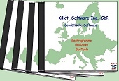 KilletSoft stellt geodätische Software für hochpräzise Koordinatentransformationen und für die Verarbeitung raumbezogener Informationen her.
Mit unserer Software können Sie für alle Länder der Welt Koordinaten unterschiedlicher Koordinatensysteme und Bezugssysteme transformieren.
Koordinatendateien verschiedener Formate lassen sich mit großer Präzision und Geschwindigkeit in andere Koordinatensysteme übertragen.
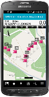
Sie können mit unserer Software auf Ihrem Notebook GPS-Koordinaten empfangen und zeitgleich in ein beliebiges Koordinatensystem umrechnen.
Andere Software eignet sich zum Erzeugen eigener Bezugssysteme mit sieben Transformationsparametern der Räumlichen Helmert Transformation.
Dafür reichen schon einige identische Punkte in verschiedenen Systemen aus.
Weitere Programme eignen sich zur Recherche ortsbezogener Daten und zur Analyse, Visualisierung und Manipulation von NTv2-Dateien.
 KilletSoft ist kompetenter Dienstleister rund um das Thema Digitale Geodaten und beratender Ansprechpartner für die Einbindung und Verwendung raumbezogener Informationen.
Unser Angebot an Geodaten deckt ein breites Spektrum räumlicher Anwendungen ab, wird laufend aktualisiert, liegt in vielen Datenformaten vor und ist sofort verfügbar.
Wir bieten georeferenzierte Orte, Ortsteile, Postleitzahlen, Telefonvorwahlen sowie Naturräume, Landschaften, Klimadaten und Schnee- und Windlastzonen der Bundesrepublik Deutschland an.
Alle Datenbanken können mit hierarchischen Verwaltungseinheiten, verschiedenen Koordinatensystemen und vielen ergänzenden Informationen geliefert werden.
Unsere Datenbanken mit georeferenzierten Objekten sind mit geographischen Koordinaten (WGS84), UTM- und Gauß-Krüger-Koordinaten und Plus-Codes hoher Genauigkeit sowie mit Geländehöhen ausgestattet.
Die von uns gelieferten Daten können zu akzeptablen Preisen in Ihre eigenen Applikationen eingebaut werden.
 KilletSoft stellt Entwicklungskomponenten für die Einbindung geodätischer Aufgaben und raumbezogener Informationen in eigene geodätische Programme, Applikationen und GIS-Software zur Verfügung.
Das Geodetic Development Kit GeoDLL ermöglicht präzise 2D- und 3D-Koordinatentransformationen und Datums- bzw. Bezugssystemwechsel mit vordefinierten Helmert Parametern, NTv2-Dateien und mit EPSG-Codes.
Die aktuellen und historischen Koordinaten- und Bezugssysteme aller Staaten der Europäischen Union, Nordamerikas, Kanadas, Australiens und der meisten anderen Länder werden weltweit unterstützt.
GeoDLL enthält außerdem einfach anzuwendende Funktionen zu vielen Themen wie zum Beispiel Meridianstreifenwechsel, benutzerdefinierte Koordinatenbezugssysteme, Entfernungsberechnungen, digitale Höhenmodelle, geodätische Hauptaufgaben, Zeitzonen, geodätische Umformungen und mehr.
Darüber hinaus stellt GeoDLL leistungsfähige Funktionen für die Generierung, Analyse, Visualisierung und Manipulation von NTv2-Dateien und Helmert Sieben Parameter Sätzen zur Verfügung.
 Damit Sie immer gut informiert sind, haben wir in dieser Spalte aktuelle Hinweise, Informationen und besondere Angebote für Sie zusammengestellt.
 Lesen Sie mehr...
Lesen Sie das Arbeitsblatt...
Lesen Sie das Arbeitsblatt...
Lesen Sie das Arbeitsblatt...
Lesen Sie unsere Info...
Lesen Sie die Pressemeldung... Zur NTv2-Sammlung...
neue Sprachen hinzugefügt werden.
Jeder Interessierte kann eine neue Sprachdatei für sich und alle Nutzer in seine Muttersprache übersetzen.
Lesen Sie mehr...
Lesen Sie das Arbeitsblatt...
Lesen Sie das Arbeitsblatt...
Lesen Sie das Arbeitsblatt...
Lesen Sie unsere Info...
Lesen Sie die Pressemeldung... Zur NTv2-Sammlung...
neue Sprachen hinzugefügt werden.
Jeder Interessierte kann eine neue Sprachdatei für sich und alle Nutzer in seine Muttersprache übersetzen.

