


 Ausführliche Beschreibung der aktuellen Version
 Liste der Koordinaten- und Bezugssysteme NTv2-Unterstützung
Mehrsprachigkeit
Benutzeroberfläche
Preise TRANSDATpro
Liste der Koordinaten- und Bezugssysteme NTv2-Unterstützung
Mehrsprachigkeit
Benutzeroberfläche
Preise TRANSDATpro
 Download
Bestellung
Download
Bestellung
 Historie der Änderungen und Ergänzungen


Seit 1993 ist das Koordinatentransformationsprogramm TRANSDATpro von KilletSoft die erste Wahl für GIS-Profis, Vermessungsingenieure, Geographen und Geodäten auf der ganzen Welt. Seitdem hat TRANSDATpro in steigendem Maße an Popularität gewonnen und hat seinen Ruf als eines der besten Programme für Koordinatenkonvertierungen auf dem Markt ausgebaut. TRANSDATpro bietet viele zusätzliche Geomatik-Tools wie geodätische 2D- / 3D-Transformationen, NTv2- und HARN-Gitterverschiebungen, GPS-Empfangsmodul, Berücksichtigung der Kontinentaldrift, INSPIRE und EPSG-Unterstützung und die Fähigkeit, individuell passende Transformationsparameter zu verwenden. TRANSDATpro ist mit vielen Verbesserungen im Laufe der Jahre gewachsen und profitiert kontinuierlich von Anwender-Feedback. Dank der zahlreichen Verbesserungsvorschläge der Nutzer erhöhen sich die Qualität und der Funktionsumfang des Programms ständig.

 Neben den gebräuchlichen Geoinformationssystemen (GIS) gibt es eine Vielzahl von geodätischen Anwendungen und Datensammlungen, die zur Erfassung, Bearbeitung und Präsentation räumlicher Daten eingesetzt werden.
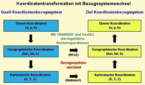
Die damit verwendeten Geodaten liegen in unterschiedlichsten Koordinatensystemen und Bezugssystemen (CRS) vor.
Hier wird das Programm TRANSDATpro benötigt, um Geodaten aus verschiedenen Datenquellen und Datenstrukturen von einem Koordinatenbezugssystem bzw. Koordinatenreferenzsystem (CRS) in ein anderes zu transformieren.
TRANSDATpro ist auf Grundlage des Geodetic Development Kit GeoDLL entwickelt worden, mit dem geodätische Berechnungen in eigene Computerprogramme eingebunden werden können.
Neben den gebräuchlichen Geoinformationssystemen (GIS) gibt es eine Vielzahl von geodätischen Anwendungen und Datensammlungen, die zur Erfassung, Bearbeitung und Präsentation räumlicher Daten eingesetzt werden.
Die damit verwendeten Geodaten liegen in unterschiedlichsten Koordinatensystemen und Bezugssystemen (CRS) vor.
Hier wird das Programm TRANSDATpro benötigt, um Geodaten aus verschiedenen Datenquellen und Datenstrukturen von einem Koordinatenbezugssystem bzw. Koordinatenreferenzsystem (CRS) in ein anderes zu transformieren.
TRANSDATpro ist auf Grundlage des Geodetic Development Kit GeoDLL entwickelt worden, mit dem geodätische Berechnungen in eigene Computerprogramme eingebunden werden können.
TRANSDATpro ist eine professionelle Software für geodätische Koordinatentransformationen zwischen internationalen und landesspezifischen Koordinatensystemen in hoher Qualität und mit großer Geschwindigkeit:
In einigen Ländern, hier ein Beispiel für Deutschland, sind die dort verfügbaren Koordinatenbezugssysteme in weitere Gruppen aufgeschlüsselt:
Eine vollständige Liste der unterstützten Koordinaten- und Bezugssysteme steht im Internet und in der Dokumentation nach dem Download (siehe oben) der kostenlosen Testversion zur Verfügung.
TRANSDATpro unterstützt alle von der INSPIRE-Richtlinie vorgeschriebenen ETRS89-Umrechnungen mit NTv2-Gitterdaten, z.B. Gauß-Krüger / DHDN nach UTM / ETRS89 mit BeTA2007. Der NTv2-Standard mit nationalen Gitterdateien für den Datumsübergang wird weltweit unterstützt. Die Verwendung der EPSG-Codes für die Koordinatenbezugssysteme ist möglich. Neben den vielen vor eingestellten Systemen können auch beliebige Koordinatensysteme und geodätische Bezugssysteme nach Helmert (Bursa / Wolf, ISO 19111) oder Molodensky definiert werden. Das Programm ist für die Direkteingabe von Koordinaten, für die Bearbeitung von Koordinatendateien (Text, CSV, SDF, dBase, KML, GPX, ArcShape und ArcGenerate) und für die Stapelverarbeitung (Batch) eingerichtet. ArcShape-Dateien können im programminternen Shape-Betrachter angesehen werden. Eine programmierbare GPS-Schnittstelle ermöglicht das Einlesen von Koordinaten aus einer preiswerten GPS-Antenne ins Notebook.
Das Programm hat eine umschaltbare mehrsprachige Benutzeroberfläche und ein ausführliches elektronisches Handbuch. Das Programm ist netzwerkfähig und unterstützt Terminal-Services auf WINDOWS-Servern. Bei einer Netzwerkinstallation werden die Clients vom Programm automatisch installiert.
Für die Koordinatentransformation verwendet das Programm TRANSDATpro Formeln, die auf Grundlage der EPSG-Spezifikationen und Publikationen von Schatz, Schuhr und Klotz sowie Hooijberg entwickelt worden sind. Für die landesspezifischen Koordinatentransformationen werden auch Algorithmen verwendet, die aus Publikationen der Vermessungsbehörden oder ähnlichen seriösen Institutionen dieser Länder übernommen worden sind oder direkt von diesen zur Verfügung gestellt worden sind. Es kommen ausschließlich strenge Formeln zum Einsatz, mit denen hochgenaue Berechnungen durchgeführt werden können.
Die Koordinatentransformationen ohne Wechsel des geodätischen Bezugssystems sind mit maximalen Abweichungen im Millimeterbereich sehr genau. Beispielhaft sind die vom Landesvermessungsamt Nordrhein-Westfalen veröffentlichten Berechnungen zwischen geographischen Koordinaten, Gauß-Krüger- und UTM-Koordinaten mit dem Programm TRANSDATpro nachvollzogen worden. Dabei konnten lediglich Abweichungen im unteren Millimeterbereich festgestellt werden.
Für eine Aussage über die Genauigkeit wurden Vergleichsberechnungen mit einem Satz Testdaten der "Arbeitsgemeinschaft der Vermessungsverwaltungen der Länder der Bundesrepublik Deutschland" (ADV) durchgeführt.
Dabei konnten lediglich Abweichungen unter 0,2 Millimeter festgestellt werden.
Bitte lesen Sie dazu den Testbericht.
Eine weitere interessante Testreihe zur Qualitätsprüfung wurde vom Netzbetreiber Westnetz GmbH mit einer extremen NTv2-Datei durchgeführt.
Mehr als 4,3 Millionen Punkte wurden mit TRANSDATpro / GeoDLL und einer Referenzsoftware von Gauß-Krüger/DHDN90 nach UTM/ETRS89 transformiert und anschließend verglichen.
Dabei gab es nur sehr wenige Abweichungen größer als einen Millimeter.
Diese betrafen nur Koordinaten, die außerhalb des Wertebereichs der NTv2-Datei lagen.
Das Testergebnis und Aussagen zur Geschwindigkeit der Berechnungen finden Sie in unserer Veröffentlichung.
Die dem Programm TRANSDATpro zugrunde liegende GeoDLL ist in C++ geschrieben und unter Microsoft Visual Studio entwickelt worden.
Dadurch werden extrem schnelle Ausführung, kompakter Code und hohe Laufstabilität erreicht.
Zusätzlich zu den unter obigen Link aufgeführten von TRANSDATpro standardmäßig unterstützten Koordinatensystemen können benutzerdefinierte Koordinatensysteme durch die Eingabe der erforderlichen Transformationsparameter benutzt werden.
Bei der Wahl eines Koordinatensystems wird automatisch das "passende" Bezugssystem vorgegeben. Die unter obigen Link aufgeführten Bezugssysteme können aber auch frei für das Quellkoordinatensystem und für das Zielkoordinatensystem als Datumsübergang eingestellt werden. Um Koordinaten in regionale Netze oder spezielle Systeme umzurechnen, ist die Verwendung beliebiger Bezugssysteme für Koordinatentransformationen möglich. Dazu können als Transformationsparameter drei Verschiebungen, drei Drehungen und ein Maßstabsfaktor nach Helmert (Datumsübergang mit sieben Parametern als "Coordinate Frame Rotation" oder als "Position Vector Transformation") oder drei Verschiebungen nach Molodensky (Datumsübergang mit drei Parametern) eingegeben werden.
Benutzerdefinierte Koordinatensysteme und benutzerdefinierte Bezugssysteme erfordern die Definition dazu passender Erdellipsoide. Die Definition erfolgt durch die Auswahl vordefinierte Ellipsoide oder durch die Eingabe der Halbradien der Quell- und Zielellipsoide.
Genaue Datumsübergänge in lokalen Systemen können durch die Verwendung von Gitterdateien nach dem NTv2-Standard durchgeführt werden.
Die Einstellung der Kontinente, Länder, Koordinatensysteme, Bezugssysteme und Meridianstreifen kann durch die direkte Eingabe von  EPSG-Codes vereinfacht werden.
Die Quellkoordinaten können direkt im Programmfenster eingegeben und den zuvor vorgenommenen Einstellungen entsprechend ad hoc umgerechnet werden. Neben der Darstellung im Programmfenster schreibt das Programm die Quell- und die berechneten Zielkoordinaten automatisch in eine Protokolldatei, die zur Auswertung mit anderer Software herangezogen werden kann.
Von größter Bedeutung ist die schnelle Umrechnung großer Koordinatenmengen aus Dateien verschiedener Formate. TRANSDATpro selektiert die Koordinaten aus Text-, CSV-, SDF-, dBase-, ArcShape- und ArcGenerate-Eingabedateien. Eine Vielzahl von Einstellungsmöglichkeiten erlauben die Anpassung der in den Eingabedateien verwendeten Datenstruktur. Die umgerechneten Koordinaten können wahlweise in Text-, CSV-, SDF-, dBase-, KML-, GPX-, ArcShape- und ArcGenerate-Ausgabedateien abgelegt werden. Auch für die Form der in der Ausgabedatei abzulegenden Koordinaten existieren zahlreiche Einstellungsmöglichkeiten.
Bei der Dateibearbeitung ist die uneingeschränkte Konvertierung zwischen den oben genannten Datenformaten mit oder ohne Koordinatentransformation möglich. In ArcShape-Dateien abgelegte Geometrien können im programminternen Shape-Betrachter dargestellt werden. In KML- und GPX-Dateien abgelegte Geometrien können direkt in Google Earth dargestellt werden.
Die Konvertierung der Datenformate ermöglicht beispielsweise die Übertragung der in ArcView- oder SrcShape-Dateien und in ArcGenerate-Dateien enthaltenen Geometrien in KML- und GPX-Dateien, die in Google Maps / Earth und OpenStreetMap verwendet werden können. Ein weiteres interessantes Beispiel ist die Transformation der Geometrien in ArcShape- und ArcGenerate-Dateien in andere Koordinatensysteme. TRANSDATpro ist in der Lage zwischen ArcGenerate-Dateien, ArcShape-Dateien und KML- und GPX-Dateien zu konvertieren und dabei Punkt-, Linien- und Polygon-Shapes zu berücksichtigen.
Besonders leistungsfähig ist das zeilenweise Kopieren von Inhalten aus Text-Dateien, wobei die transformierten Koordinaten anstelle der ursprünglichen Koordinaten in den Text eingesetzt werden. Auch die Suche nach in Texten verstreut angeordneten Koordinaten und deren Umrechnung ist möglich. Die Flexibilität des Programms TRANSDATpro eröffnet eine Vielzahl von weiteren Konvertierungsmöglichkeiten, wie z.B. die Verwendung von Filtern.
Die Stapelverarbeitung (Batch) ermöglicht das automatische Abarbeiten einer oder mehrerer Dateien mithilfe einer Stapeldatei. Dadurch ist das Programm TRANSDATpro aus anderen Programmen heraus steuerbar oder es kann unbeaufsichtigt große Mengen von Koordinaten transformieren.
Shape-Dateien der GIS ArcView und ARC/INFO können unter Beibehaltung der internen Datenstruktur direkt in ein anderes Koordinatensystem umgerechnet werden. Bei der Dateibearbeitung ist die uneingeschränkte Konvertierung zwischen den Datenformaten Text, CSV, SDF, dBase, KML, GPX, ArcShape und ArcGenerate mit oder ohne Koordinatentransformation möglich. TRANSDATpro kann ArcGenerate und ArcShape Punkt-, Linien- und Polygon-Geometrien in KML- und GPX-Dateien übertragen. In KML- und GPX-Dateien abgelegte Geometrien können direkt in Google Earth dargestellt werden. In ArcShape-Dateien vorhandene Geometrien können im programminternen Shape-Betrachter dargestellt werden.
Das Programm TRANSDATpro ist mit einer zeitgemäßen graphischen Benutzeroberfläche ausgestattet, deren Handhabung intuitiv zu begreifen ist.
Für jedes Fenster werden ausführliche Hilfetexte angeboten.
Das ausführliche elektronische Handbuch des Programms TRANSDATpro liegt in Deutscher und in Englischer Sprache vor.
Die Benutzeroberfläche kann jedoch in vielen Sprachen dargestellt werden.
Zu diesem Zweck werden externe Sprachdateien verwendet.
Beim Programmaufruf stellt das Programm fest, welche Sprachdateien im Aufrufverzeichnis vorhanden sind.
Die gefundenen Sprachen werden in einer Auswahlliste zur Verfügung gestellt.
Durch das Anlegen neuer Sprachdateien können jederzeit neue Sprachen durch die Anwender zum Programm TRANSDATpro hinzugefügt werden.
Das Programm ist auf den gebräuchlichen Computernetzwerken netzwerkfähig. Die Client-Installationen erfolgen automatisch. Das Programm unterstützt die Nutzung der Terminal-Services auf WINDOWS-Servern wie z. B. "Citrix Terminal Server".
Das Programm hat eine integrierte GPS-Schnittstelle zum Erfassen von Koordinaten, Geschwindigkeiten und Bewegungsrichtungen mit Hilfe einer preiswerten GPS-Antenne, die an eine serielle- oder USB-Schnittstelle angeschlossen ist. In einem Graphikfenster werden bis zu 2500 GPS-Positionen dargestellt.
Es ist möglich, die von TRANSDATpro verwendeten geodätischen Funktionen für Koordinatentransformationen per WINDOWS-DLL (Dynamic Link Library) in eigene Programme einzubinden.
Alle in TRANSDATpro verwendeten Transformationen und Berechnungen sind in unserem Geodetic Development Kit GeoDLL enthalten.
Der Einsatz der GeoDLL in eigenen Applikationen spart den hohen Zeiteinsatz und einen Teil der Kosten für die Entwicklung der Routinen zur Koordinatentransformation ein.
Da das Programm TRANSDATpro eine recht anspruchsvolle Anwendung ist, sind zum einwandfreien Betrieb einige Anforderungen an die Hardware zu berücksichtigen. Zum Betrieb des Programms wird ein Personal Computer mit einem Prozessortyp benötigt, der mindestens der Leistungsklasse eines Pentium-Prozessors entspricht. Der noch freie Arbeitsspeicher sollte mindestens 32 Megabyte groß sein. Als Betriebssysteme kommen Microsoft WINDOWS 2000 / NT / XP / Vista / 7 / 8 und kompatible Betriebssysteme in Frage.
Preise und Bezugsquellen für dieses und andere Programme entnehmen Sie bitte der Preisliste.
Die möglichen Lizenzmodelle sind auf der Seite Lizenz aufgeführt.
Bestellen Sie das Programm mit dem elektronischen Bestellformular.
Eine kostenlose Testversion des Programms mit dem ausführlichen Benutzerhandbuch kann als ZIP-gepackte Datei vom Internet heruntergeladen werden.
Geschäftsführer Fred Killet erklärt, warum Sie niemals eine illegale Version unseres geodätischen Programms TRANSDATpro verwenden sollten.
 Damit Sie immer gut informiert sind, haben wir in dieser Spalte aktuelle Hinweise, Informationen und besondere Angebote für Sie zusammengestellt.
 Lesen Sie mehr...
Lesen Sie das Arbeitsblatt...
Lesen Sie das Arbeitsblatt...
Lesen Sie das Arbeitsblatt...
Lesen Sie unsere Info...
Lesen Sie die Pressemeldung... Zur NTv2-Sammlung...
neue Sprachen hinzugefügt werden.
Jeder Interessierte kann eine neue Sprachdatei für sich und alle Nutzer in seine Muttersprache übersetzen.
Lesen Sie mehr...
Lesen Sie das Arbeitsblatt...
Lesen Sie das Arbeitsblatt...
Lesen Sie das Arbeitsblatt...
Lesen Sie unsere Info...
Lesen Sie die Pressemeldung... Zur NTv2-Sammlung...
neue Sprachen hinzugefügt werden.
Jeder Interessierte kann eine neue Sprachdatei für sich und alle Nutzer in seine Muttersprache übersetzen.