The group "Time Zone Calculations" contains functions to calculate time zones, UTC, DST, daylight change dates and other Time Zone parameters from coordinates or from GeoDLL time zone indexes.
Time Zones
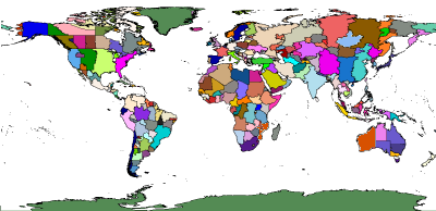
A time zone is a region that has an uniform standard time for legal, commercial, and social purposes. There are more than 400 different Time Zones all over the world. They all are primarily longitude dependent, but secondary they follow the boundaries of countries or their administrative subdivisions. GeoDLL calculates Time Zones from geographic coordinates (longitude, latitude). The correct Time Zone is detected also in the peripheral regions of the zone surfaces with high precision. Optional the 3, 12, 24 and 200 mile territorial limits can be included in the calculations. Time Zones supported by GeoDLL are based on an uniform naming convention, designed by Paul Eggert, such as America/New_York and Europe/Paris. The Time Zones have offsets from Coordinated Universal Time (UTC) as a number of hours. Many higher latitude countries use Daylight Saving Time (DST) for a part of the year, typically by changing clocks one hour forward. Unfortunately, the start and end dates of Daylight Saving Time in many countries are handled differently. GeoDLL calculates the time zone parameters UTC, DST and the start and end dates of the Daylight Saving Period for all countries and Time Zones.
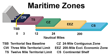
GeoDLL calculates Time Zones alternatively including the Territorial Sea Baseline, the Three Mile Territorial Limit, the Twelve Mile Territorial Limit, the 24-Mile Contiguous Zone and the 200-Mile Exclusive Economic Zone. Outside these Maritime Zones, international offshore Time Zones with the designations Alpha to Zulu are calculated.
The Sea Baseline follows the low-water line along the coast of a state. It is the base to measure the seaward limits of a state's territorial sea and all other Maritime Zones. From country to country different the Three and Twelve Mile Territorial Limits define sea areas which are regarded as the sovereign territory of the state. In the 24-Mile Contiguous Zone a state can exert limited control, for example police powers with respect to immigration and customs control. Inside the 200-Mile Exclusive Economic Zone a state has control of all economic resources, for example fishing, mining of natural resources and exploration.