Killet GeoSoftware Ing.-GbR - short: KilletSoft - is a software company, which was established in the year 1991.
The society is divided into the ranges "Geodetic Standard Software", "Development Tools for Geoinformatics" and "German Geodata".
The focal trades of the companies supplied by KilletSoft are consulting engineers, GIS developers, Internet marketing, public utilities, logistics, telecommunications, security and public services.
Spatial Data by KilletSoft
 KilletSoft distributes Geodata of The Federal Rebublic of Germany with georeferences, which refer to spatial structure objects with different resolutions.
The georeferences are present as coordinates of towns and urban districts, postal code areas, dialling codes areas, nature areas, landscapes and climatic zones.
In each case they are linked with the suitable hierarchical political units and additional data.
The georeferences are contained as geographical coordinates, UTM coordinates, Gauss Krueger coordinates and Plus-Codes and with orthometric ground elevations.
The databases are intensively maintained to ensure constant topicality and are updated at least once a year.
KilletSoft distributes Geodata of The Federal Rebublic of Germany with georeferences, which refer to spatial structure objects with different resolutions.
The georeferences are present as coordinates of towns and urban districts, postal code areas, dialling codes areas, nature areas, landscapes and climatic zones.
In each case they are linked with the suitable hierarchical political units and additional data.
The georeferences are contained as geographical coordinates, UTM coordinates, Gauss Krueger coordinates and Plus-Codes and with orthometric ground elevations.
The databases are intensively maintained to ensure constant topicality and are updated at least once a year.
Please click on a product name to get a short product description, current version details and further information.
-
 Geodata Germany - Detailed Locality Database
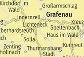
Geodata of the Federal Republic of Germany with georeferenced towns and municipalities, urban districts, postal codes, dialling codes for navigation, geocoding, proximity searches and distance computations and with landscape, nature area, climatical and cartographical contents.

In order that you are always well informed about our company, we write actual news, current information and special offers here into this column.
pur
 Geodata Germany
All georeferenced databases has been updated to the data conditions of January 1st, 2024.
The database tables of "GeoData Germany" contain all German towns, municipalities and urban districts, coordinates, postal codes, dialling codes, administrative units, nature areas, landscapes, travel areas, wind and snow loads, solar irradiation, cartographies info etc.
 Read more...
New work sheet
Display Formats of UTM Coordinates.
Display formats, calculation methods and the historical background of the UTM coordinate system.
Third revised edition of the popular technical article.
Read the work sheet...
New work sheet
What actually is a Coordinate Reference System?
Explanation of the Coordinate Reference System with the components Coordinate System, Reference System, Reference Definition and Reference Frame.
Second revised edition.
Read the work sheet...
Illegal software versions
The illegal use of our software got out of control!
Read our Info...
is member of

Translators wanted!
The programs TRANSDAT, SEVENPAR, NTv2Creator, NTv2Poly and NTv2Tools support language files for the programs interface.
Since the language dependent texts are managed in external files,
new languages can be added at any time by creating new language files.
Everybody who is interested can translate a new language file into his native language for himself and all users.
Author: Dipl.-Ing. Fred Killet
Page name: h_geod_e.htm
Page views: 336
Period: since Januar 1, 2024

